Table of contents (7 sections)
Panda Habitat Corridors: Conservation Success and What the Data Shows
I have spent three decades walking panda forests in southwestern China, and I can tell you the moment the conversation changed. The question used to be whether. Whether pandas would use a corridor. Whether a narrow strip of restored forest — damp bamboo, deep shade, the smell of wet earth — could overcome the fragmentation that decades of logging and farmland had carved into their range. Academic papers, conservation plans, and grant proposals all circled the same question: should we build corridors?
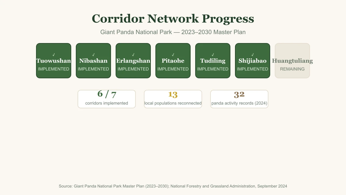
Now we have built them. The Giant Panda National Park has designated seven key ecological corridors connecting isolated panda populations, and six are now implemented — reconnecting 13 previously isolated local populations. Camera traps in the corridor restoration areas have recorded panda activity 32 times since monitoring began. Fecal DNA samples are being collected to track whether genes are finally moving between populations that have been separated for generations. As a wildlife ecologist who participated in the IUCN assessment of panda status, I can tell you this is the rare conservation success story with data behind it.
This is a conservation success report. The question is no longer whether corridors work. It is how far they can scale.
The Fragmentation Baseline: 33 Isolated Populations
To understand what the corridor network is accomplishing, you need the baseline. The Fourth National Giant Panda Survey, conducted between 2011 and 2014, found 33 isolated subpopulations across six mountain ranges. Twenty-two of those were “small populations” — fewer than 30 pandas each. Below that threshold, long-term genetic viability is shaky. Inbreeding depression, stochastic population crashes, and the simple arithmetic of finding a mate all work against a population that small.
That was the problem: not simply fewer pandas, but separated pandas. When a single road, a reservoir, or a swath of farmland cuts through panda habitat, it severs far more than a migration route. It splits breeding pools. It silences gene flow. It leaves small populations drifting toward genetic isolation.
I am not going to re-teach the corridor mechanism here — the habitat fragmentation story, the physical design of corridors, the edge effects, the bamboo species questions — because our earlier piece, Panda Habitat Fragmentation and Wildlife Corridors, covers that ground in detail. What I want to document is what happens after you build one.
Three Evidence Levels: Usage, Genetics, Population
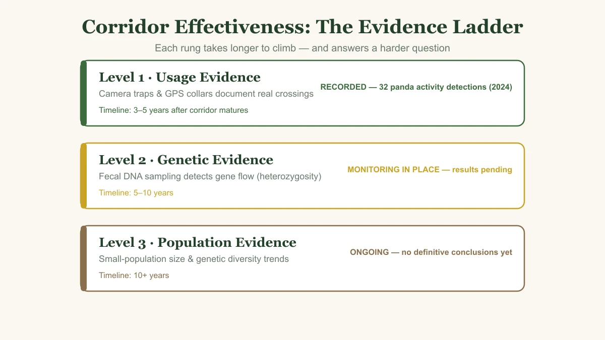
Corridor effectiveness is not a single measurement. It is a ladder of evidence, and each rung takes longer to climb than the last. I have used this framework in my own field work, and it is the only honest way to answer “are corridors actually working?”
Level 1 — Usage Evidence: Camera Traps and GPS Collars
The first sign that a corridor is functioning is simple: animals use it.
The flagship case is the Nibashan corridor in the Daxiangling range. Infrared cameras were deployed there in late 2017, and in autumn 2019 they photographed the first panda cub. Cub-rearing activity has now been recorded in seven consecutive years of monitoring — the kind of on-the-ground record that led the National Forestry and Grassland Administration to report, in September 2024, that panda activity had been recorded 32 times across the Tuowushan, Nibashan, and Erlangshan corridor restoration areas.
Equally telling is what else shows up in the camera images. Sympatric mammals and birds — takin, tufted deer, golden pheasant, serow, Asiatic black bear, leopard cat — are moving through the restored corridors as well. A corridor that works for pandas works for the whole forest community. That is the umbrella species argument made visible with a shutter click.
Camera traps and GPS collars are the first word, not the final verdict. Animals can pass through a corridor without breeding across it. For that, we need the next level.
Level 2 — Genetic Evidence: Fecal DNA and Gene Flow
The more rigorous test is genetic. Non-invasive fecal DNA sampling allows us to identify individuals and measure whether genes are flowing between previously isolated populations.
The scientific design is in place. The park’s corridor monitoring includes fecal DNA collection for genetic analysis, with published gene-flow results still awaiting verification. I want to be precise here: we are not yet publishing gene-flow percentages or heterozygosity numbers from the corridor network. What matters is that the sampling infrastructure exists — the corridor program is being monitored with a scientific question, not just with hope.
Level 3 — Population Evidence: Small-Population Trends
The ultimate metric is population-level recovery. Do previously isolated populations grow larger? Does their genetic diversity improve? Are the smallest subpopulations — those 22 populations with fewer than 30 pandas — stabilizing or shrinking?
This is the slowest evidence level, requiring a decade or more of monitoring. Population trends integrate everything: survival, reproduction, dispersal, and genetic health. It will be years before we can say with confidence that the corridor network has rescued a specific small population from genetic decline. But the monitoring infrastructure is in place, and that is more than most large-mammal conservation programs can claim.
What the Giant Panda National Park Is Actually Doing
This is not a small experiment. The Giant Panda National Park, established in 2021 and planned to cover more than 27,000 square kilometers, is the largest single-species protected-area experiment in the world. It administers the corridor program: seven key corridors designated under its 2023–2030 Master Plan, six implemented, reconnecting 13 local panda populations.
The park’s legal framework, formalized in 2021 from a 2017 pilot, gives it land-use authority over corridor zones. Land is acquired through direct purchase, long-term lease, or conservation easements. This matters. A corridor drawn on a map is not a corridor; the physical space has to be secured, restored, and defended from re-encroachment. Protective boundary designation is not the same as active management — the legal tools for land acquisition are what give the corridor network its teeth.
Local communities are part of the implementation, working as corridor forest rangers. That is not a minor detail. Protected areas are only as effective as their management, and management depends on the people who live inside and around the habitat. You can see the geographic footprint of this on our giant panda national park page and explore the broader habitat map here.
The scale remains a work in progress. Six implemented corridors out of seven designated is a strong start, but completing the network will require sustained funding, negotiation, and ecological restoration. The easy connections are likely the ones already built. The harder ones — across wider valleys and busier roads — will test the limits.
The 2016 Downgrade: A Rare Success, Still Reversible
In September 2016, the International Union for Conservation of Nature downlisted the giant panda from Endangered to Vulnerable. It was a rare, headline-making conservation success, based on an estimated 1,864 wild pandas and an 11.8% expansion of occupied habitat.
I was part of that assessment, and I can tell you the debate was not about whether the pandas had recovered — the data was clear. The debate was about whether the recovery would last. The downlisting was the official recognition of decades of habitat protection. But the corridor program is what protects those gains from being reversed. Habitat fragmentation is still the greatest threat to panda populations; the 2016 decision did not eliminate that. It simply gave us the breathing room to engage with it properly. For the full context, see our article on the endangered-to-vulnerable IUCN status change.
Evidence-based optimism is warranted here. But it is optimism anchored to monitoring data, not to narrative.
From “Does It Work” to “How Far”
The corridor network has entered a new phase. The outcome timeline is now visible:
- Usage evidence typically appears 3–5 years after a corridor matures. The documented crossings in the Tuowushan, Nibashan, and Erlangshan restoration areas sit inside that window.
- Genetic flow evidence appears 5–10 years, measured through fecal DNA. The park’s monitoring program is built on that timeline, though published results are still awaited.
- Population evidence requires 10 years or more — trends in small-population size and genetic diversity.
This means a crucial point for conservation funders and policymakers: no immediate effect is not failure. Patience is built into the monitoring timeline. A corridor that has not yet produced a camera-trap crossing at year two may still be on schedule. The question is whether the monitoring is actually being done, not whether the corridor has yet produced a panda sighting.
Scaling the success means several things. The obvious path is completing the remaining key corridors — moving from six implemented toward the full network of seven designated. It also means widening existing corridors where wildlife use is concentrated. And in places where corridors intersect roads, underpasses and overpasses will be needed to maintain connectivity.
But the most important scaling is transparency. We should prioritize corridor projects that have public, auditable monitoring data — not just planning commitments. A corridor with a camera trap and a published detection record is worth more than ten corridors with press releases. This is the practical decision rule I bring to my own evaluations of conservation programs: support projects with outcome-verification mechanisms, not projects with only planning commitments.
Quick Reference: Corridor Evidence Status
| Evidence Level | Indicator | Timeline | Current Status |
|---|---|---|---|
| Usage | Camera trap / GPS collar crossings | 3–5 years after corridor maturity | 32 panda activity records in the Tuowushan, Nibashan, and Erlangshan restoration areas (National Forestry and Grassland Administration, September 2024). Nibashan: first cub photographed autumn 2019; cub-rearing recorded across seven consecutive years. |
| Genetic | Fecal DNA gene flow / heterozygosity | 5–10 years | Monitoring program in place; published gene-flow results awaiting verification. |
| Population | Small-population size / diversity trend | 10+ years | Monitoring ongoing; no definitive population-level conclusions yet. |
| Corridor Program | Implemented corridors | N/A | 7 key corridors designated (2023–2030 Master Plan); 6 implemented; 13 local populations reconnected (September 2024). |
Frequently Asked Questions
Are panda habitat corridors actually working?
Yes — the evidence is emerging. The National Forestry and Grassland Administration reported in September 2024 that panda activity had been recorded 32 times in the Tuowushan, Nibashan, and Erlangshan corridor restoration areas. The clearest documented case is the Nibashan corridor, where infrared cameras first photographed a panda cub in autumn 2019 and cub-rearing activity has been recorded in seven consecutive years of monitoring. Usage evidence typically appears 3–5 years after a corridor matures; genetic flow recovery is measured over 5–10 years via fecal DNA analysis. The corridor program is a genuine conservation success in progress, not a completed one.
How do scientists measure corridor effectiveness?
Through three evidence levels: 1. usage evidence — camera traps and GPS collars document actual crossings; 2. genetic evidence — non-invasive fecal DNA sampling detects gene flow (increased heterozygosity) between previously isolated populations; 3. population evidence — trends in small-population size and genetic diversity over time. The park’s monitoring program is designed around this ladder; published gene-flow results from the corridor network are still awaiting verification.
How many panda corridors are operational?
Under the Giant Panda National Park Master Plan (2023–2030), seven key ecological corridors have been designated — Tuowushan, Nibashan, Erlangshan, Pitaohe, Tudiling, Shijiabao, and Huangtuliang. As of September 2024, six had been implemented, reconnecting 13 previously isolated local panda populations. The most documented corridor is Nibashan, where the first panda cub was photographed in autumn 2019 and cub-rearing activity has continued across seven consecutive years.
What is the Giant Panda National Park doing for corridors?
The Giant Panda National Park (established 2021, planned to cover more than 27,000 km² — the largest single-species protected-area experiment in the world) administers the corridor program: seven key corridors designated under its 2023–2030 Master Plan, six implemented, reconnecting 13 local panda populations. Its legal framework, formalized from the 2017 pilot, gives it land-use authority over corridor zones, acquired through direct purchase, long-term lease, and conservation easements, with local communities engaged as corridor forest rangers.
The corridor network is proof that conservation can work. The panda’s recovery has always been framed as a story of captive breeding and protected habitat — and those elements matter. But the next chapter is being written in the corridors: narrow stretches of restored forest where the long-separated branches of a fragmented species are beginning, slowly, to reconnect.
That is what outcome verification looks like. It is not a happy ending. It is a monitored trajectory — and one we can still choose to support.
Explore the map to see where panda habitat is protected and where the remaining corridors are needed: Panda Habitat Map.
For the full story on the fragmentation problem, read the companion piece: Panda Habitat Fragmentation and Wildlife Corridors.
To understand how camera traps and infrared monitoring produce the evidence used in corridor science: Panda Forest Rangers and Infrared Monitoring.
And for why protecting pandas protects an entire mammal community: The Panda as Umbrella Species and Biodiversity Protection.
Dr. James Thornton
Wildlife Ecology Editor
Wildlife ecologist specializing in forest ecology, protected area effectiveness, mammal community conservation, and human-wildlife coexistence in panda habitats.
View full profile →Tags in this article
Questions readers often ask
Are panda habitat corridors actually working?
Yes — the evidence is emerging. The National Forestry and Grassland Administration reported in September 2024 that panda activity had been recorded 32 times in the Tuowushan, Nibashan, and Erlangshan corridor restoration areas. The clearest documented case is the Nibashan corridor, where infrared cameras first photographed a panda cub in autumn 2019 and cub-rearing activity has been recorded in seven consecutive years of monitoring. Usage evidence typically appears 3–5 years after a corridor matures; genetic flow recovery is measured over 5–10 years via fecal DNA analysis. The corridor program is a genuine conservation success in progress, not a completed one.
How do scientists measure corridor effectiveness?
Through three evidence levels: 1. usage evidence — camera traps and GPS collars document actual crossings; 2. genetic evidence — non-invasive fecal DNA sampling detects gene flow (increased heterozygosity) between previously isolated populations; 3. population evidence — trends in small-population size and genetic diversity over time. The park's monitoring program is designed around this ladder; published gene-flow results from the corridor network are still awaiting verification.
How many panda corridors are operational?
Under the Giant Panda National Park Master Plan (2023–2030), seven key ecological corridors have been designated — Tuowushan, Nibashan, Erlangshan, Pitaohe, Tudiling, Shijiabao, and Huangtuliang. As of September 2024, six had been implemented, reconnecting 13 previously isolated local panda populations. The most documented corridor is Nibashan, where the first panda cub was photographed in autumn 2019 and cub-rearing activity has continued across seven consecutive years.
What is the Giant Panda National Park doing for corridors?
The Giant Panda National Park (established 2021, planned to cover more than 27,000 km² — the largest single-species protected-area experiment in the world) administers the corridor program: seven key corridors designated under its 2023–2030 Master Plan, six implemented, reconnecting 13 local panda populations. Its legal framework, formalized from the 2017 pilot, gives it land-use authority over corridor zones, acquired through direct purchase, long-term lease, and conservation easements, with local communities engaged as corridor forest rangers.